
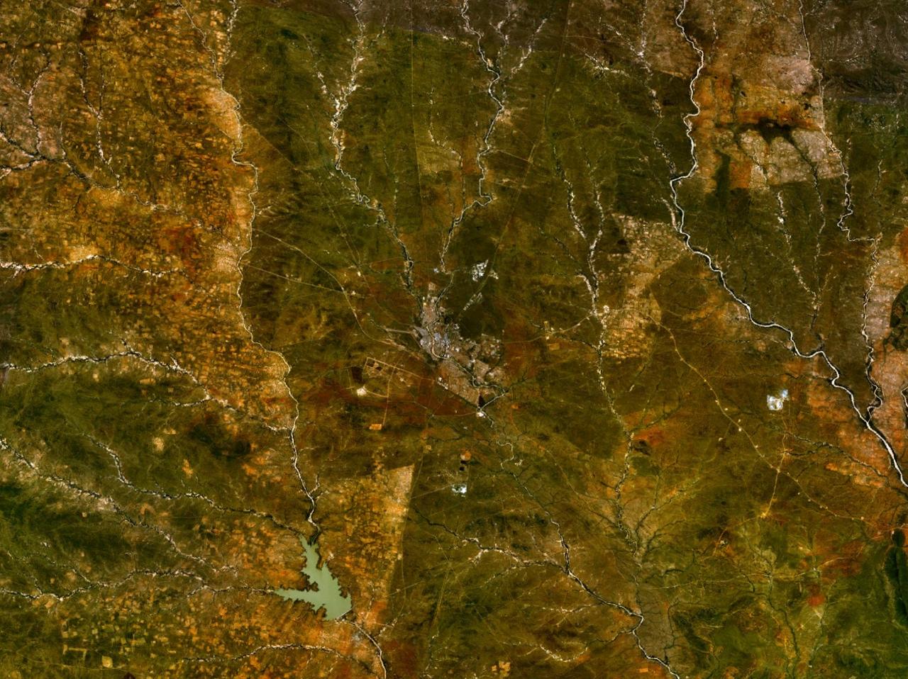
Setshwantsho:Francistown 27.51670E 21.16674S.jpg
Selekanyo sa tshedimoso ye: 800 × 599 pixels. Tse dingwe resolutions: 320 × 240 pixels | 640 × 479 pixels | 1,024 × 766 pixels | 1,280 × 958 pixels.
Faele ya konokono (1,280 × 958 pixels, file size: 244 KB, MIME type: image/jpeg)
NASA World Wind screenshot.
| This image is in the public domain because it is a screenshot from NASA’s globe software World Wind using a public domain layer, such as Blue Marble, MODIS, Landsat, SRTM, USGS or GLOBE.
|
 |
Segologolo sa setshwantsho
Tbetsa letsatsi/nako go bone faele jaaka ene e ntse ka nako eo.
| Letsatsi/Nako | Thumbnail | Dikarolwana | Modirisi | Comment | |
|---|---|---|---|---|---|
| ya jaanong | 11:51, 15 Motsheganong 2005 | | 1,280 × 958 (244 KB) | Rex | NASA World Wind screenshot. {{PD-USGov-NASA}} Category:Maps of Botswana |
Tiriso ya setshwantsho
There are no pages that use this file.
Tiriso ya file ka karetso
Di wiki tse dingwe di dirisa setshwantsho se
- Dirisa mo af.wikipedia.org
- Dirisa mo ar.wikipedia.org
- Dirisa mo ast.wikipedia.org
- Dirisa mo be.wikipedia.org
- Dirisa mo ceb.wikipedia.org
- Dirisa mo cs.wikipedia.org
- Dirisa mo da.wikipedia.org
- Dirisa mo de.wikipedia.org
- Dirisa mo de.wikivoyage.org
- Dirisa mo el.wikipedia.org
- Dirisa mo en.wikipedia.org
- Dirisa mo en.wikivoyage.org
- Dirisa mo eu.wikipedia.org
- Dirisa mo fr.wikipedia.org
- Dirisa mo fr.wikivoyage.org
- Dirisa mo he.wikivoyage.org
- Dirisa mo hy.wikipedia.org
- Dirisa mo it.wikipedia.org
- Dirisa mo it.wikivoyage.org
- Dirisa mo ja.wikipedia.org
- Dirisa mo ja.wikivoyage.org
- Dirisa mo ka.wikipedia.org
- Dirisa mo ko.wikipedia.org
- Dirisa mo lt.wikipedia.org
- Dirisa mo lv.wikipedia.org
- Dirisa mo nl.wikipedia.org
- Dirisa mo no.wikipedia.org
- Dirisa mo pl.wikipedia.org
- Dirisa mo ro.wikipedia.org
- Dirisa mo ru.wikipedia.org
- Dirisa mo tr.wikipedia.org
- Dirisa mo uk.wikipedia.org
- Dirisa mo vep.wikipedia.org
- Dirisa mo war.wikipedia.org
- Dirisa mo www.wikidata.org
- Dirisa mo zh.wikivoyage.org