
Setshwantsho:North West 2011 population density map.svg

Size of this PNG preview of this SVG file: 800 × 548 pixels. Tse dingwe resolutions: 320 × 219 pixels | 640 × 439 pixels | 1,024 × 702 pixels | 1,280 × 877 pixels | 2,560 × 1,755 pixels | 1,208 × 828 pixels.
Faele ya konokono (SVG file, nominally 1,208 × 828 pixels, file size: 996 KB)
Tshoboko
| Tlhaloso |
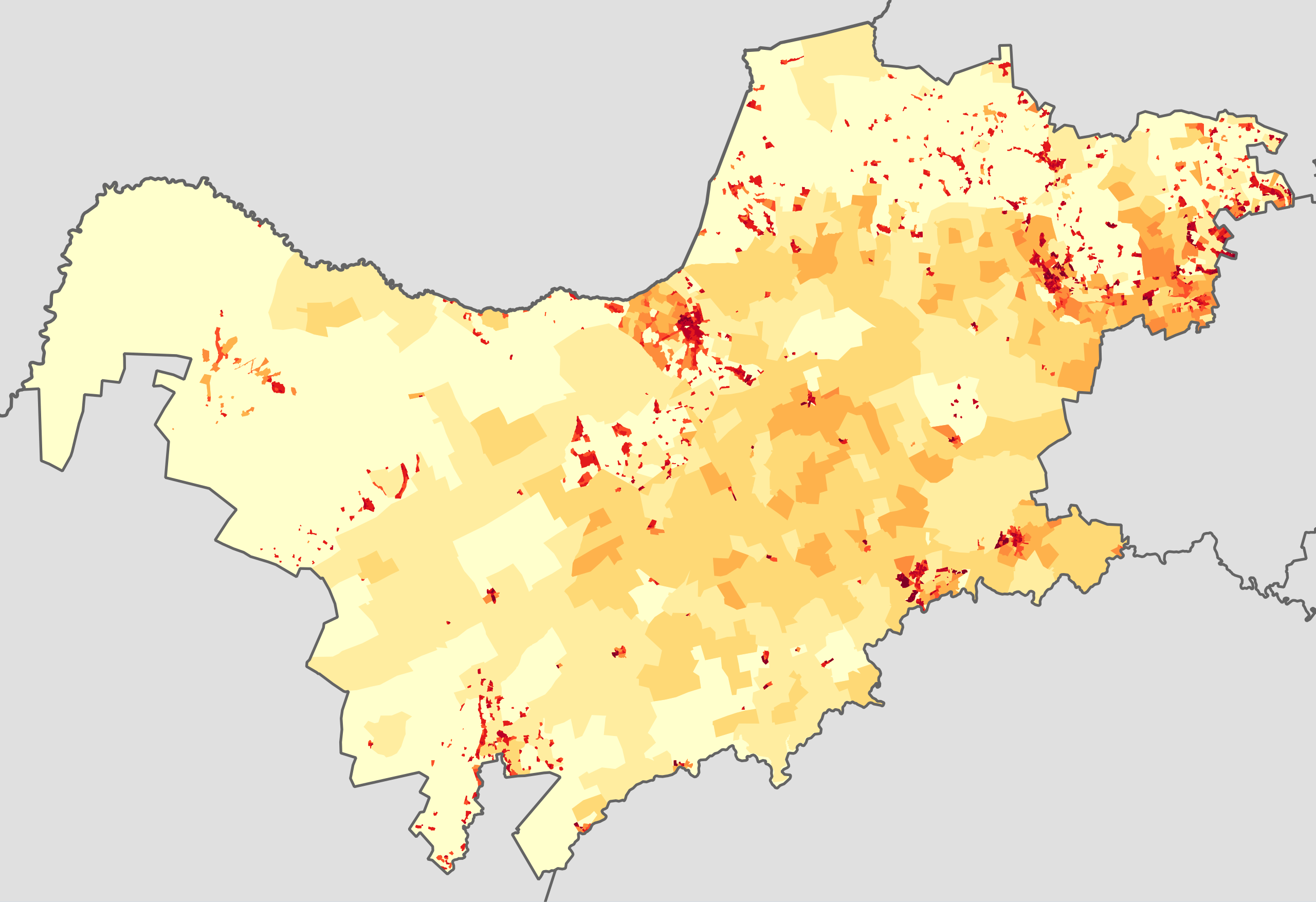
English: Population density map of the North West province of South Africa, from the 2011 Census, at the "Small Area" level.
<1 inhabitant/km²
1–3 inhabitants/km²
3–10 inhabitants/km²
10–30 inhabitants/km²
30–100 inhabitants/km²
100–300 inhabitants/km²
300–1000 inhabitants/km²
1000–3000 inhabitants/km²
>3000 inhabitants/km²
Projection is Albers Equal-Area Conic, with standard parallels at 25.5° S and 31.5° S, and origin at 28.5° S 25.5° E. |
| Letsatsi | |
| Motswedi | Statistics South Africa's Census 2011 is the source of the basic population data. The map results from my own processing of the data. |
| Mokwadi | Htonl |
| Teta (Reusing this file) |
http://beta2.statssa.gov.za/?page_id=425 |
Licensing
The following license applies to the population data on which the map is based:

|
The copyright holder of this file, Statistics South Africa (States SA), allows anyone to use it for any purpose, provided that the copyright holder is properly attributed. Redistribution, derivative work, commercial use, and all other use is permitted. |
Attribution:
Statistics South Africa (States SA)
|
The following tag applies to the map itself:
| I, the copyright holder of this work, release this work into the public domain. This applies worldwide. In some countries this may not be legally possible; if so: I grant anyone the right to use this work for any purpose, without any conditions, unless such conditions are required by law. |
Segologolo sa setshwantsho
Tbetsa letsatsi/nako go bone faele jaaka ene e ntse ka nako eo.
| Letsatsi/Nako | Thumbnail | Dikarolwana | Modirisi | Comment | |
|---|---|---|---|---|---|
| ya jaanong | 20:34, 22 Phalane 2013 | | 1,208 × 828 (996 KB) | Htonl | == {{int:filedesc}} == {{Information |Description={{en|1=Population density map of the North West province of South Africa, from the 2011 Census, at the "Small Area" level. {{legend|#ffffcc|<1 inhabitant/km²}} {{legend|#ffeda0|1–3 inhabitants/km... |
Tiriso ya setshwantsho
The following page uses this file:
Tiriso ya file ka karetso
Di wiki tse dingwe di dirisa setshwantsho se
- Dirisa mo be.wikipedia.org
- Dirisa mo en.wikipedia.org
- Dirisa mo he.wikipedia.org
- Dirisa mo hy.wikipedia.org
- Dirisa mo ka.wikipedia.org
- Dirisa mo ru.wikipedia.org