
Setshwantsho:South Polar Cap of Mars during Martian South summer 2000.jpg

Selekanyo sa tshedimoso ye: 800 × 584 pixels. Tse dingwe resolutions: 320 × 234 pixels | 640 × 467 pixels | 1,024 × 748 pixels | 1,280 × 935 pixels | 1,690 × 1,234 pixels.
Faele ya konokono (1,690 × 1,234 pixels, file size: 139 KB, MIME type: image/jpeg)
| Tlhaloso |
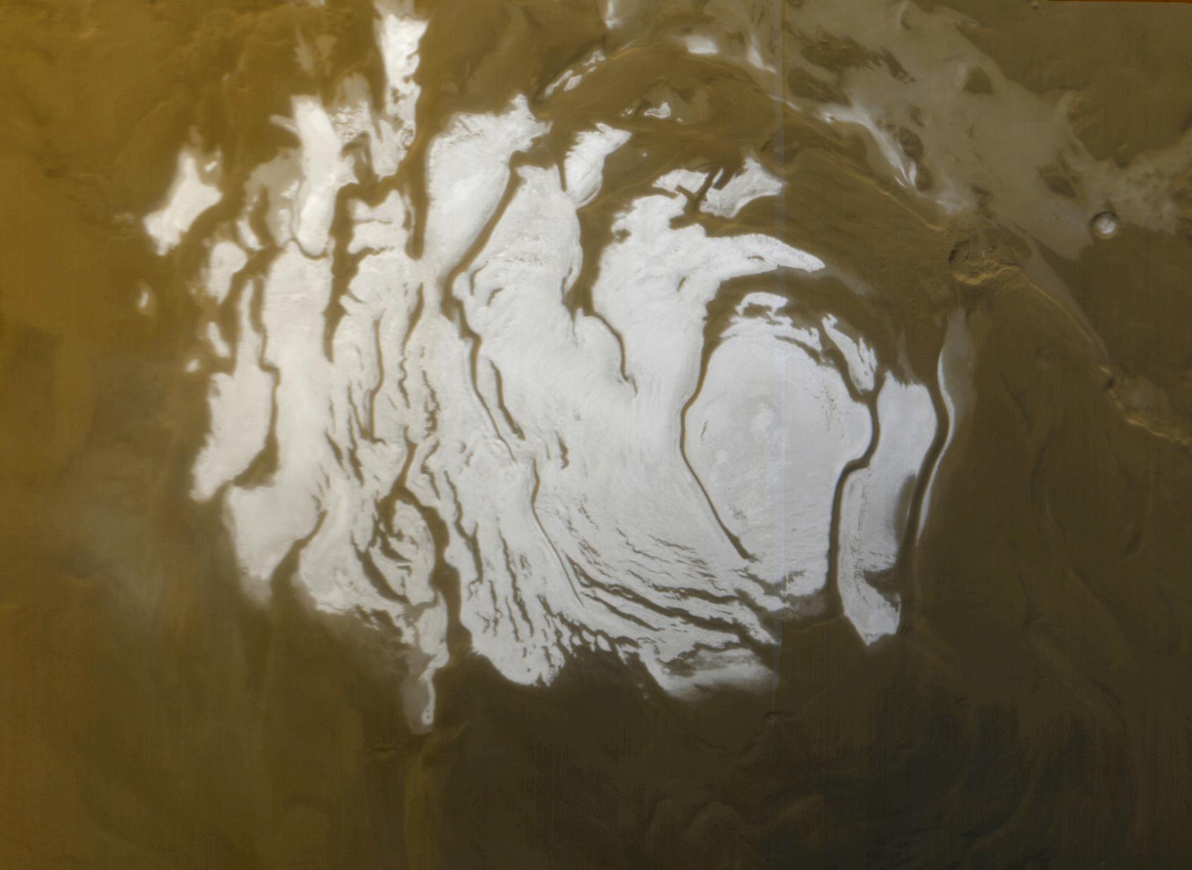
English: This is the south polar cap of Mars as it appeared to the Mars Global Surveyor (MGS) Mars Orbiter Camera (MOC) on April 17, 2000. The polar cap from left to right is about 420 km (260 mi) across.
Ελληνικά: Η νότια πολική περιοχή του πλανήτη Άρη. Εικόνα από τη διαστημοσυσκευή Mars Global Surveyor. Διακρίνεται εύκολα το κάλυμμα πάγου του Νότιου Πόλου, που εδώ έχει διάμετρο περίπου 420 km. Η φωτογραφία έχει ληφθεί κατά τη διάρκεια του καλοκαιρού στο Νότιο ημισφαίριο, κι έτσι η έκταση του πάγου είναι η ελάχιστη που σημειώνεται, καθώς κατά τη διάρκεια του καλοκαιριού το κάλυμμα πάγου στους πόλους του Άρη συρρικνώνεται. Κατά το χειμώνα, ολόκληρη η περιοχή που φαίνεται στη φωτογραφία σκεπάζεται με πάγο.
Original captionThis is the south polar cap of Mars as it appeared to the Mars Global Surveyor (MGS) Mars Orbiter Camera (MOC) on April 17, 2000. In winter and early spring, this entire scene would be covered by frost. In summer, the cap shrinks to its minimum size, as shown here. Even though it is summer, observations made by the Viking orbiters in the 1970s showed that the south polar cap remains cold enough that the polar frost (seen here as white) consists of carbon dioxide. Carbon dioxide freezes at temperatures around -125° C (-193° F). Mid-summer afternoon sunlight illuminates this scene from the upper left from about 11.2° above the horizon. Soon the cap will experience sunsets; by June 2000, this pole will be in autumn, and the area covered by frost will begin to grow. Winter will return to the south polar region in December 2000. The polar cap from left to right is about 420 km (260 mi) across. |
|||||
| Letsatsi | ||||||
| Motswedi | http://photojournal.jpl.nasa.gov/catalog/PIA02393 http://www.msss.com/mars_images/moc/4_27_00_spcap/ file | |||||
| Mokwadi | NASA/JPL/MSSS | |||||
| Teta (Reusing this file) |
|

This image or video was catalogued by Jet Propulsion Laboratory of the United States National Aeronautics and Space Administration (NASA) under Photo ID: PIA02393. This tag does not indicate the copyright status of the attached work. A normal copyright tag is still required. See Commons:Licensing. Other languages:
|
Segologolo sa setshwantsho
Tbetsa letsatsi/nako go bone faele jaaka ene e ntse ka nako eo.
| Letsatsi/Nako | Thumbnail | Dikarolwana | Modirisi | Comment | |
|---|---|---|---|---|---|
| ya jaanong | 12:10, 2 Phalane 2011 | | 1,690 × 1,234 (139 KB) | Badseed | {{Information |Description={{en|This is the south polar cap of Mars as it appeared to the Mars Global Surveyor (MGS) Mars Orbiter Camera (MOC) on April 17, 2000. The polar cap from left to right is about 420 km (260 mi) across.}} {{el|Η νότια πολ |
Tiriso ya setshwantsho
There are no pages that use this file.
Tiriso ya file ka karetso
Di wiki tse dingwe di dirisa setshwantsho se
- Dirisa mo ar.wikipedia.org
- Dirisa mo az.wikipedia.org
- Dirisa mo ca.wikipedia.org
- Dirisa mo de.wikipedia.org
- Dirisa mo el.wikipedia.org
- Dirisa mo en.wikipedia.org
- Dirisa mo en.wikiversity.org
- Dirisa mo es.wikipedia.org
- Dirisa mo et.wikipedia.org
- Dirisa mo eu.wikipedia.org
- Dirisa mo fa.wikipedia.org
- Dirisa mo fr.wikipedia.org
- Dirisa mo he.wikipedia.org
- Dirisa mo hi.wikipedia.org
- Dirisa mo hr.wikipedia.org
- Dirisa mo hu.wikipedia.org
- Dirisa mo id.wikipedia.org
- Dirisa mo kw.wikipedia.org
- Dirisa mo mnw.wikipedia.org
- Dirisa mo pl.wikipedia.org
- Dirisa mo pt.wikipedia.org
- Dirisa mo pt.wikibooks.org
- Dirisa mo ru.wikipedia.org
- Dirisa mo simple.wikipedia.org
- Dirisa mo sl.wikipedia.org
- Dirisa mo sr.wikipedia.org
- Dirisa mo th.wikipedia.org
- Dirisa mo uk.wikipedia.org
- Dirisa mo vi.wikipedia.org
- Dirisa mo www.wikidata.org
View more global usage of this file.