
Setshwantsho:Map of the provinces of South Africa 1910-1976 with English labels.svg

Size of this PNG preview of this SVG file: 684 × 599 pixels. Tse dingwe resolutions: 274 × 240 pixels | 548 × 480 pixels | 876 × 768 pixels | 1,168 × 1,024 pixels | 2,337 × 2,048 pixels | 809 × 709 pixels.
Faele ya konokono (SVG file, nominally 809 × 709 pixels, file size: 393 KB)
Tshoboko
| Tlhaloso |
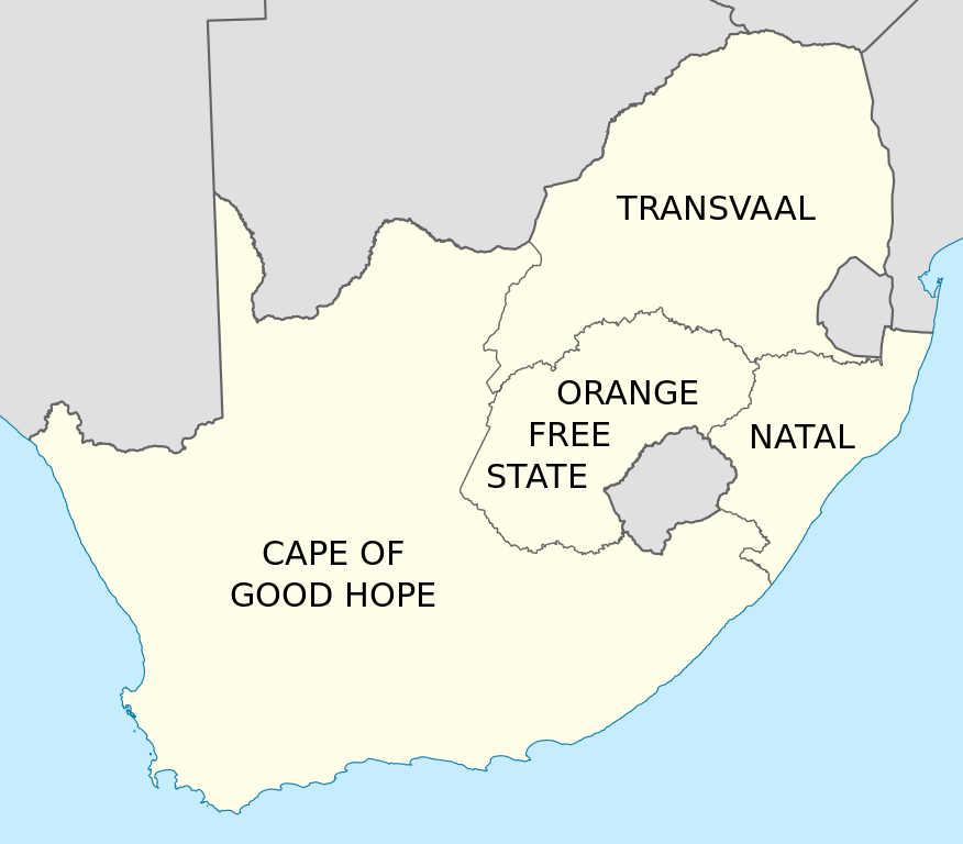
English: Map of South Africa showing the provinces as they were from 1910 to 1976, with labels in English. Based on File:Map of South Africa with provincial borders 1910-1976.svg. |
| Letsatsi | |
| Motswedi | Tiro ya gago |
| Mokwadi | Htonl |
| Other versions | File:Map of South Africa with provincial borders 1910-1976.svg, File:Kaart van die provinsies van Suid-Afrika 1910-1976 met Afrikaanse byskrifte.svg |
Licensing
I, the copyright holder of this work, hereby publish it under the following licenses:
This file is licensed under the Creative Commons Attribution-Share Alike 3.0 Unported license.
- O gololosegile:
- to share – to copy, distribute and transmit the work
- to remix – to adapt the work
- Under the following conditions:
- Go neelwa – You must give appropriate credit, provide a link to the license, and indicate if changes were made. You may do so in any reasonable manner, but not in any way that suggests the licensor endorses you or your use.
- go abelana ka go tshwana – If you remix, transform, or build upon the material, you must distribute your contributions under the same or compatible license as the original.

|
Permission is granted to copy, distribute and/or modify this document under the terms of the GNU Free Documentation License, Version 1.2 or any later version published by the Free Software Foundation; with no Invariant Sections, no Front-Cover Texts, and no Back-Cover Texts. A copy of the license is included in the section entitled GNU Free Documentation License. |
You may select the license of your choice.
Segologolo sa setshwantsho
Tbetsa letsatsi/nako go bone faele jaaka ene e ntse ka nako eo.
| Letsatsi/Nako | Thumbnail | Dikarolwana | Modirisi | Comment | |
|---|---|---|---|---|---|
| ya jaanong | 23:55, 7 Mopitlo 2011 | | 809 × 709 (393 KB) | Htonl | == Summary == {{Information |Description ={{en|1=Map of South Africa showing the provinces as they were from 1910 to 1976, with labels in English. Based on File:Map of South Africa with provincial borders 1910-1976.svg.}} |Source ={{own}} |
Tiriso ya setshwantsho
The following page uses this file:
Tiriso ya file ka karetso
Di wiki tse dingwe di dirisa setshwantsho se
- Dirisa mo af.wikipedia.org
- Dirisa mo ar.wikipedia.org
- Dirisa mo ast.wikipedia.org
- Dirisa mo azb.wikipedia.org
- Dirisa mo bn.wikipedia.org
- Dirisa mo ca.wikipedia.org
- Dirisa mo de.wikipedia.org
- Dirisa mo en.wikipedia.org
- Dirisa mo es.wikipedia.org
- Dirisa mo id.wikipedia.org
- Dirisa mo it.wikipedia.org
- Dirisa mo ml.wikipedia.org
- Dirisa mo ms.wikipedia.org
- Dirisa mo nl.wikipedia.org
- Dirisa mo pl.wikipedia.org
- Dirisa mo ro.wikipedia.org
- Dirisa mo sl.wikipedia.org
- Dirisa mo sw.wikipedia.org
- Dirisa mo th.wikipedia.org
- Dirisa mo tr.wikipedia.org
- Dirisa mo uk.wikipedia.org
- Dirisa mo zh.wikipedia.org